

SPC Day 1 Fire Weather Outlook
2025-04-27
SPC Day Fire Weather Outlook
SPC Day 1 Fire Weather Outlook
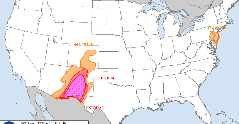
Day 1 Fire Weather Outlook
NWS Storm Prediction Center Norman OK
1138 AM CDT Sun Apr 27 2025

Valid 271700Z - 281200Z

...EXTREMELY CRITICAL FIRE WEATHER AREA FOR CENTRAL AND SOUTHERN NEW
MEXICO INTO FAR WEST TEXAS...
...CRITICAL FIRE WEATHER AREA FOR MUCH OF CENTRAL NEW MEXICO INTO
FAR WEST TEXAS...

...Southeast Pennsylvania and New Jersey...
Elevated highlights were added across portions of southeastern
Pennsylvania and New Jersey where strong offshore flow within a
post-frontal regime is ongoing. Northwest winds of 15-25 mph with
gusts up to 40 mph combined with relative humidity falling into the
25-35 percent range are expected through the early afternoon before
winds subside late afternoon. Rainfall over the last 48 hours was
spotty so pockets of receptive fuels remain, primarily in the New
Jersey Pinelands.

...Southwest and adjacent High Plains...
Significant fire weather threat remains across the Southwest with
swath of Extremely Critical highlights in place across much of
southern and central New Mexico. Elevated highlights were extended
into far southeastern Utah and far western Colorado to account for
some lower elevation receptive fuels. Otherwise, previous forecast
(see below) remains on track.

..Williams.. 04/27/2025

.PREV DISCUSSION... /ISSUED 0109 AM CDT Sun Apr 27 2025/

...Synopsis...
With a mid-level trough translating across the Intermountain West,
and a lee cyclone deepening over the central High Plains, strong
surface winds and deep boundary layer mixing are forecast across
much of the Southwest into the southern High Plains. Critical to
Extremely Critical fire-weather conditions are expected across much
of southern and central New Mexico, into portions of far West Texas.


...Central/Southern New Mexico into Far West Texas...
Widespread 30+ MPH winds and 5-10% relative humidity is anticipated
over much of southern, central, and even portions of eastern New
Mexico. While dry and windy conditions are anticipated further east
of the current highlights, recent wetting rainfall in eastern New
Mexico over the last several days will serve to limit the
receptiveness of fuels to wildfire ignition and spread. Therefore,
Critical and Extremely Critical highlights have been confined to
where fuels guidance shows ERCs exceeding the 90th annual
percentile, primarily across southern and central New Mexico.

...Eastern Colorado...
Elevated highlights have been maintained over eastern Colorado,
where dormant/fine fuels are anticipated to be receptive to wildfire
ignition and spread with an environment characterized by 10%
relative humidity and 15-20 MPH winds. Some recent wetting rainfall
has occurred across eastern Colorado, with areas receiving 0.75-2.0
inches of rainfall in the last 48 hours. The Elevated highlights in
this update reflect the driest areas receiving little to no
rainfall.

...Please see www.spc.noaa.gov/fire for graphic product...
SPC Day 1 Fire Weather Outlook
Day 1 Fire Weather Outlook
NWS Storm Prediction Center Norman OK
1138 AM CDT Sun Apr 27 2025

Valid 271700Z - 281200Z

...EXTREMELY CRITICAL FIRE WEATHER AREA FOR CENTRAL AND SOUTHERN NEW
MEXICO INTO FAR WEST TEXAS...
...CRITICAL FIRE WEATHER AREA FOR MUCH OF CENTRAL NEW MEXICO INTO
FAR WEST TEXAS...

...Southeast Pennsylvania and New Jersey...
Elevated highlights were added across portions of southeastern
Pennsylvania and New Jersey where strong offshore flow within a
post-frontal regime is ongoing. Northwest winds of 15-25 mph with
gusts up to 40 mph combined with relative humidity falling into the
25-35 percent range are expected through the early afternoon before
winds subside late afternoon. Rainfall over the last 48 hours was
spotty so pockets of receptive fuels remain, primarily in the New
Jersey Pinelands.

...Southwest and adjacent High Plains...
Significant fire weather threat remains across the Southwest with
swath of Extremely Critical highlights in place across much of
southern and central New Mexico. Elevated highlights were extended
into far southeastern Utah and far western Colorado to account for
some lower elevation receptive fuels. Otherwise, previous forecast
(see below) remains on track.

..Williams.. 04/27/2025

.PREV DISCUSSION... /ISSUED 0109 AM CDT Sun Apr 27 2025/

...Synopsis...
With a mid-level trough translating across the Intermountain West,
and a lee cyclone deepening over the central High Plains, strong
surface winds and deep boundary layer mixing are forecast across
much of the Southwest into the southern High Plains. Critical to
Extremely Critical fire-weather conditions are expected across much
of southern and central New Mexico, into portions of far West Texas.


...Central/Southern New Mexico into Far West Texas...
Widespread 30+ MPH winds and 5-10% relative humidity is anticipated
over much of southern, central, and even portions of eastern New
Mexico. While dry and windy conditions are anticipated further east
of the current highlights, recent wetting rainfall in eastern New
Mexico over the last several days will serve to limit the
receptiveness of fuels to wildfire ignition and spread. Therefore,
Critical and Extremely Critical highlights have been confined to
where fuels guidance shows ERCs exceeding the 90th annual
percentile, primarily across southern and central New Mexico.

...Eastern Colorado...
Elevated highlights have been maintained over eastern Colorado,
where dormant/fine fuels are anticipated to be receptive to wildfire
ignition and spread with an environment characterized by 10%
relative humidity and 15-20 MPH winds. Some recent wetting rainfall
has occurred across eastern Colorado, with areas receiving 0.75-2.0
inches of rainfall in the last 48 hours. The Elevated highlights in
this update reflect the driest areas receiving little to no
rainfall.

...Please see www.spc.noaa.gov/fire for graphic product...
4:52 pmApril 27, 2025
SPC Day 1 Fire Weather Outlook
2025-04-27
SPC Day Fire Weather Outlook
SPC Day 1 Fire Weather Outlook
Day 1 Fire Weather Outlook
NWS Storm Prediction Center Norman OK
1138 AM CDT Sun Apr 27 2025

Valid 271700Z - 281200Z

...EXTREMELY CRITICAL FIRE WEATHER AREA FOR CENTRAL AND SOUTHERN NEW
MEXICO INTO FAR WEST TEXAS...
...CRITICAL FIRE WEATHER AREA FOR MUCH OF CENTRAL NEW MEXICO INTO
FAR WEST TEXAS...

...Southeast Pennsylvania and New Jersey...
Elevated highlights were added across portions of southeastern
Pennsylvania and New Jersey where strong offshore flow within a
post-frontal regime is ongoing. Northwest winds of 15-25 mph with
gusts up to 40 mph combined with relative humidity falling into the
25-35 percent range are expected through the early afternoon before
winds subside late afternoon. Rainfall over the last 48 hours was
spotty so pockets of receptive fuels remain, primarily in the New
Jersey Pinelands.

...Southwest and adjacent High Plains...
Significant fire weather threat remains across the Southwest with
swath of Extremely Critical highlights in place across much of
southern and central New Mexico. Elevated highlights were extended
into far southeastern Utah and far western Colorado to account for
some lower elevation receptive fuels. Otherwise, previous forecast
(see below) remains on track.

..Williams.. 04/27/2025

.PREV DISCUSSION... /ISSUED 0109 AM CDT Sun Apr 27 2025/

...Synopsis...
With a mid-level trough translating across the Intermountain West,
and a lee cyclone deepening over the central High Plains, strong
surface winds and deep boundary layer mixing are forecast across
much of the Southwest into the southern High Plains. Critical to
Extremely Critical fire-weather conditions are expected across much
of southern and central New Mexico, into portions of far West Texas.


...Central/Southern New Mexico into Far West Texas...
Widespread 30+ MPH winds and 5-10% relative humidity is anticipated
over much of southern, central, and even portions of eastern New
Mexico. While dry and windy conditions are anticipated further east
of the current highlights, recent wetting rainfall in eastern New
Mexico over the last several days will serve to limit the
receptiveness of fuels to wildfire ignition and spread. Therefore,
Critical and Extremely Critical highlights have been confined to
where fuels guidance shows ERCs exceeding the 90th annual
percentile, primarily across southern and central New Mexico.

...Eastern Colorado...
Elevated highlights have been maintained over eastern Colorado,
where dormant/fine fuels are anticipated to be receptive to wildfire
ignition and spread with an environment characterized by 10%
relative humidity and 15-20 MPH winds. Some recent wetting rainfall
has occurred across eastern Colorado, with areas receiving 0.75-2.0
inches of rainfall in the last 48 hours. The Elevated highlights in
this update reflect the driest areas receiving little to no
rainfall.

...Please see www.spc.noaa.gov/fire for graphic product...
4:46 pmApril 27, 2025

SPC Day 2 Fire Weather Outlook
2025-04-27
SPC Day Fire Weather Outlook
SPC Day 2 Fire Weather Outlook
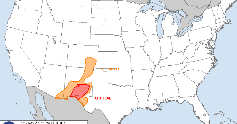
Day 2 Fire Weather Outlook
NWS Storm Prediction Center Norman OK
0243 PM CDT Sun Apr 27 2025

Valid 281200Z - 291200Z

...CRITICAL FIRE WEATHER AREA FOR SOUTHERN NEW MEXICO INTO FAR WEST
TEXAS...

...Southern New Mexico into far west Texas...
A lingering mid-level jet atop a very dry, well-mixed boundary layer
will result in west-southwest surface winds of 15-25 mph in addition
to single digit relative humidity across southern New Mexico into
far western Texas Monday afternoon. These conditions amid ERC values
at or exceeding the 97th percentile supports the addition of
Critical highlights.

...Southeastern Colorado...
Enhanced downslope winds and drying will support at least an
Elevated fire weather threat across southeastern Colorado through
early afternoon where the fuels seasonal green-up has been delayed.
Expect west-southwest surface winds of 15-20 mph and localized
single digit relative humidity through early afternoon before a dry
cold front arrives overnight.

..Williams.. 04/27/2025

.PREV DISCUSSION... /ISSUED 0358 AM CDT Sun Apr 27 2025/

...Synopsis...
A lingering mid-level trough over the western U.S. (and its
associated southwest flow), along with deep boundary layer mixing,
will result in at least Elevated fire-weather conditions across
portions of central and eastern New Mexico on Monday.

...Central and Eastern New Mexico...
With receptive fuels (ERCs exceeding the 80th-90th annual
percentiles) and dry, windy conditions across much of central and
eastern New Mexico, at least Elevated fire-weather conditions are
expected. 00Z HREF guidance suggests that there is potential for
Critical conditions, particularly across central New Mexico, but
there is enough ensemble spread in the HREF to preclude adding
highlights at this time. While the dry and windy conditions are
likely to occur further east into the Texas Panhandle, recent
wetting rainfall over the last several days should limit fire
danger.

...Please see www.spc.noaa.gov/fire for graphic product...
SPC Day 2 Fire Weather Outlook
Day 2 Fire Weather Outlook
NWS Storm Prediction Center Norman OK
0243 PM CDT Sun Apr 27 2025

Valid 281200Z - 291200Z

...CRITICAL FIRE WEATHER AREA FOR SOUTHERN NEW MEXICO INTO FAR WEST
TEXAS...

...Southern New Mexico into far west Texas...
A lingering mid-level jet atop a very dry, well-mixed boundary layer
will result in west-southwest surface winds of 15-25 mph in addition
to single digit relative humidity across southern New Mexico into
far western Texas Monday afternoon. These conditions amid ERC values
at or exceeding the 97th percentile supports the addition of
Critical highlights.

...Southeastern Colorado...
Enhanced downslope winds and drying will support at least an
Elevated fire weather threat across southeastern Colorado through
early afternoon where the fuels seasonal green-up has been delayed.
Expect west-southwest surface winds of 15-20 mph and localized
single digit relative humidity through early afternoon before a dry
cold front arrives overnight.

..Williams.. 04/27/2025

.PREV DISCUSSION... /ISSUED 0358 AM CDT Sun Apr 27 2025/

...Synopsis...
A lingering mid-level trough over the western U.S. (and its
associated southwest flow), along with deep boundary layer mixing,
will result in at least Elevated fire-weather conditions across
portions of central and eastern New Mexico on Monday.

...Central and Eastern New Mexico...
With receptive fuels (ERCs exceeding the 80th-90th annual
percentiles) and dry, windy conditions across much of central and
eastern New Mexico, at least Elevated fire-weather conditions are
expected. 00Z HREF guidance suggests that there is potential for
Critical conditions, particularly across central New Mexico, but
there is enough ensemble spread in the HREF to preclude adding
highlights at this time. While the dry and windy conditions are
likely to occur further east into the Texas Panhandle, recent
wetting rainfall over the last several days should limit fire
danger.

...Please see www.spc.noaa.gov/fire for graphic product...
3:45 pmApril 27, 2025

SPC Day 2 Fire Weather Outlook
2025-04-27
SPC Day Fire Weather Outlook
SPC Day 2 Fire Weather Outlook
Day 2 Fire Weather Outlook
NWS Storm Prediction Center Norman OK
0243 PM CDT Sun Apr 27 2025

Valid 281200Z - 291200Z

...CRITICAL FIRE WEATHER AREA FOR SOUTHERN NEW MEXICO INTO FAR WEST
TEXAS...

...Southern New Mexico into far west Texas...
A lingering mid-level jet atop a very dry, well-mixed boundary layer
will result in west-southwest surface winds of 15-25 mph in addition
to single digit relative humidity across southern New Mexico into
far western Texas Monday afternoon. These conditions amid ERC values
at or exceeding the 97th percentile supports the addition of
Critical highlights.

...Southeastern Colorado...
Enhanced downslope winds and drying will support at least an
Elevated fire weather threat across southeastern Colorado through
early afternoon where the fuels seasonal green-up has been delayed.
Expect west-southwest surface winds of 15-20 mph and localized
single digit relative humidity through early afternoon before a dry
cold front arrives overnight.

..Williams.. 04/27/2025

.PREV DISCUSSION... /ISSUED 0358 AM CDT Sun Apr 27 2025/

...Synopsis...
A lingering mid-level trough over the western U.S. (and its
associated southwest flow), along with deep boundary layer mixing,
will result in at least Elevated fire-weather conditions across
portions of central and eastern New Mexico on Monday.

...Central and Eastern New Mexico...
With receptive fuels (ERCs exceeding the 80th-90th annual
percentiles) and dry, windy conditions across much of central and
eastern New Mexico, at least Elevated fire-weather conditions are
expected. 00Z HREF guidance suggests that there is potential for
Critical conditions, particularly across central New Mexico, but
there is enough ensemble spread in the HREF to preclude adding
highlights at this time. While the dry and windy conditions are
likely to occur further east into the Texas Panhandle, recent
wetting rainfall over the last several days should limit fire
danger.

...Please see www.spc.noaa.gov/fire for graphic product...
3:45 pmApril 27, 2025
SPC Day 2 Fire Weather Outlook
2025-04-27
SPC Day Fire Weather Outlook
SPC Day 2 Fire Weather Outlook
Day 2 Fire Weather Outlook
NWS Storm Prediction Center Norman OK
0243 PM CDT Sun Apr 27 2025

Valid 281200Z - 291200Z

...CRITICAL FIRE WEATHER AREA FOR SOUTHERN NEW MEXICO INTO FAR WEST
TEXAS...

...Southern New Mexico into far west Texas...
A lingering mid-level jet atop a very dry, well-mixed boundary layer
will result in west-southwest surface winds of 15-25 mph in addition
to single digit relative humidity across southern New Mexico into
far western Texas Monday afternoon. These conditions amid ERC values
at or exceeding the 97th percentile supports the addition of
Critical highlights.

...Southeastern Colorado...
Enhanced downslope winds and drying will support at least an
Elevated fire weather threat across southeastern Colorado through
early afternoon where the fuels seasonal green-up has been delayed.
Expect west-southwest surface winds of 15-20 mph and localized
single digit relative humidity through early afternoon before a dry
cold front arrives overnight.

..Williams.. 04/27/2025

.PREV DISCUSSION... /ISSUED 0358 AM CDT Sun Apr 27 2025/

...Synopsis...
A lingering mid-level trough over the western U.S. (and its
associated southwest flow), along with deep boundary layer mixing,
will result in at least Elevated fire-weather conditions across
portions of central and eastern New Mexico on Monday.

...Central and Eastern New Mexico...
With receptive fuels (ERCs exceeding the 80th-90th annual
percentiles) and dry, windy conditions across much of central and
eastern New Mexico, at least Elevated fire-weather conditions are
expected. 00Z HREF guidance suggests that there is potential for
Critical conditions, particularly across central New Mexico, but
there is enough ensemble spread in the HREF to preclude adding
highlights at this time. While the dry and windy conditions are
likely to occur further east into the Texas Panhandle, recent
wetting rainfall over the last several days should limit fire
danger.

...Please see www.spc.noaa.gov/fire for graphic product...
SPC Day 2 Fire Weather Outlook
Day 2 Fire Weather Outlook
NWS Storm Prediction Center Norman OK
0243 PM CDT Sun Apr 27 2025

Valid 281200Z - 291200Z

...CRITICAL FIRE WEATHER AREA FOR SOUTHERN NEW MEXICO INTO FAR WEST
TEXAS...

...Southern New Mexico into far west Texas...
A lingering mid-level jet atop a very dry, well-mixed boundary layer
will result in west-southwest surface winds of 15-25 mph in addition
to single digit relative humidity across southern New Mexico into
far western Texas Monday afternoon. These conditions amid ERC values
at or exceeding the 97th percentile supports the addition of
Critical highlights.

...Southeastern Colorado...
Enhanced downslope winds and drying will support at least an
Elevated fire weather threat across southeastern Colorado through
early afternoon where the fuels seasonal green-up has been delayed.
Expect west-southwest surface winds of 15-20 mph and localized
single digit relative humidity through early afternoon before a dry
cold front arrives overnight.

..Williams.. 04/27/2025

.PREV DISCUSSION... /ISSUED 0358 AM CDT Sun Apr 27 2025/

...Synopsis...
A lingering mid-level trough over the western U.S. (and its
associated southwest flow), along with deep boundary layer mixing,
will result in at least Elevated fire-weather conditions across
portions of central and eastern New Mexico on Monday.

...Central and Eastern New Mexico...
With receptive fuels (ERCs exceeding the 80th-90th annual
percentiles) and dry, windy conditions across much of central and
eastern New Mexico, at least Elevated fire-weather conditions are
expected. 00Z HREF guidance suggests that there is potential for
Critical conditions, particularly across central New Mexico, but
there is enough ensemble spread in the HREF to preclude adding
highlights at this time. While the dry and windy conditions are
likely to occur further east into the Texas Panhandle, recent
wetting rainfall over the last several days should limit fire
danger.

...Please see www.spc.noaa.gov/fire for graphic product...
3:45 pmApril 27, 2025