
SPC Day 3-8 Fire Weather Outlook
2025-04-27
SPC Day Fire Weather Outlook
SPC Day 3-8 Fire Weather Outlook
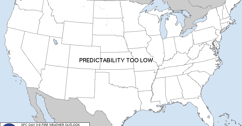
Day 3-8 Fire Weather Outlook
NWS Storm Prediction Center Norman OK
0500 PM CDT Sun Apr 27 2025

Valid 291200Z - 051200Z

...Days 3-5/Tuesday-Thursday...
A short-wave trough over the Southwest U.S. will continue to bring
lingering fire weather concerns to southern New Mexico and far west
Texas Days 3-4/Tuesday-Wednesday. 40 percent Critical probabilities
remain for Day 3/Tuesday across southern New Mexico and far Western
Texas, with fire weather threat shifting and shrinking to primarily
far western Texas by Day 4/Wednesday where available fuels remain
receptive to wildfire spread. Another upper-level wave and cold
front shift eastward across the northern Rockies for Days
3-4/Tuesday-Wednesday presenting a potential post-frontal/downslope
wind fire weather threat across eastern Montana. Spatial
distribution of frontal precipitation is a bit uncertain and
precludes introduction of Critical probabilities at this time for
Days 4-5/Wednesday-Thursday.

...Day 6-8/Friday-Sunday...
Ridge amplification over the western U.S. will support a lighter
wind regime but above normal temperatures for much of the
Intermountain West and Northwestern Tier states. Long term model and
ensemble guidance suggests another potentially strong, negatively
tilted upper-trough into the western U.S. through the weekend (Days
7-8). Attendant strong winds aloft over a well-mixed boundary layer
could present another broad fire weather concern over much of the
Southwest for the weekend time frame. 40 percent Critical
probabilities were added for eastern Arizona into western New Mexico
where drought stressed fuels remain and minimal to no precipitation
leading up to the weekend across this region is expected.

..Williams.. 04/27/2025

...Please see www.spc.noaa.gov/fire for graphic product...
SPC Day 3-8 Fire Weather Outlook
Day 3-8 Fire Weather Outlook
NWS Storm Prediction Center Norman OK
0500 PM CDT Sun Apr 27 2025

Valid 291200Z - 051200Z

...Days 3-5/Tuesday-Thursday...
A short-wave trough over the Southwest U.S. will continue to bring
lingering fire weather concerns to southern New Mexico and far west
Texas Days 3-4/Tuesday-Wednesday. 40 percent Critical probabilities
remain for Day 3/Tuesday across southern New Mexico and far Western
Texas, with fire weather threat shifting and shrinking to primarily
far western Texas by Day 4/Wednesday where available fuels remain
receptive to wildfire spread. Another upper-level wave and cold
front shift eastward across the northern Rockies for Days
3-4/Tuesday-Wednesday presenting a potential post-frontal/downslope
wind fire weather threat across eastern Montana. Spatial
distribution of frontal precipitation is a bit uncertain and
precludes introduction of Critical probabilities at this time for
Days 4-5/Wednesday-Thursday.

...Day 6-8/Friday-Sunday...
Ridge amplification over the western U.S. will support a lighter
wind regime but above normal temperatures for much of the
Intermountain West and Northwestern Tier states. Long term model and
ensemble guidance suggests another potentially strong, negatively
tilted upper-trough into the western U.S. through the weekend (Days
7-8). Attendant strong winds aloft over a well-mixed boundary layer
could present another broad fire weather concern over much of the
Southwest for the weekend time frame. 40 percent Critical
probabilities were added for eastern Arizona into western New Mexico
where drought stressed fuels remain and minimal to no precipitation
leading up to the weekend across this region is expected.

..Williams.. 04/27/2025

...Please see www.spc.noaa.gov/fire for graphic product...
6:05 pmApril 27, 2025

SPC Day 3-8 Fire Weather Outlook
2025-04-27
SPC Day Fire Weather Outlook
SPC Day 3-8 Fire Weather Outlook
Day 3-8 Fire Weather Outlook
NWS Storm Prediction Center Norman OK
0500 PM CDT Sun Apr 27 2025

Valid 291200Z - 051200Z

...Days 3-5/Tuesday-Thursday...
A short-wave trough over the Southwest U.S. will continue to bring
lingering fire weather concerns to southern New Mexico and far west
Texas Days 3-4/Tuesday-Wednesday. 40 percent Critical probabilities
remain for Day 3/Tuesday across southern New Mexico and far Western
Texas, with fire weather threat shifting and shrinking to primarily
far western Texas by Day 4/Wednesday where available fuels remain
receptive to wildfire spread. Another upper-level wave and cold
front shift eastward across the northern Rockies for Days
3-4/Tuesday-Wednesday presenting a potential post-frontal/downslope
wind fire weather threat across eastern Montana. Spatial
distribution of frontal precipitation is a bit uncertain and
precludes introduction of Critical probabilities at this time for
Days 4-5/Wednesday-Thursday.

...Day 6-8/Friday-Sunday...
Ridge amplification over the western U.S. will support a lighter
wind regime but above normal temperatures for much of the
Intermountain West and Northwestern Tier states. Long term model and
ensemble guidance suggests another potentially strong, negatively
tilted upper-trough into the western U.S. through the weekend (Days
7-8). Attendant strong winds aloft over a well-mixed boundary layer
could present another broad fire weather concern over much of the
Southwest for the weekend time frame. 40 percent Critical
probabilities were added for eastern Arizona into western New Mexico
where drought stressed fuels remain and minimal to no precipitation
leading up to the weekend across this region is expected.

..Williams.. 04/27/2025

...Please see www.spc.noaa.gov/fire for graphic product...
6:05 pmApril 27, 2025
SPC Day 3-8 Fire Weather Outlook
2025-04-27
SPC Day Fire Weather Outlook
SPC Day 3-8 Fire Weather Outlook
Day 3-8 Fire Weather Outlook
NWS Storm Prediction Center Norman OK
0500 PM CDT Sun Apr 27 2025

Valid 291200Z - 051200Z

...Days 3-5/Tuesday-Thursday...
A short-wave trough over the Southwest U.S. will continue to bring
lingering fire weather concerns to southern New Mexico and far west
Texas Days 3-4/Tuesday-Wednesday. 40 percent Critical probabilities
remain for Day 3/Tuesday across southern New Mexico and far Western
Texas, with fire weather threat shifting and shrinking to primarily
far western Texas by Day 4/Wednesday where available fuels remain
receptive to wildfire spread. Another upper-level wave and cold
front shift eastward across the northern Rockies for Days
3-4/Tuesday-Wednesday presenting a potential post-frontal/downslope
wind fire weather threat across eastern Montana. Spatial
distribution of frontal precipitation is a bit uncertain and
precludes introduction of Critical probabilities at this time for
Days 4-5/Wednesday-Thursday.

...Day 6-8/Friday-Sunday...
Ridge amplification over the western U.S. will support a lighter
wind regime but above normal temperatures for much of the
Intermountain West and Northwestern Tier states. Long term model and
ensemble guidance suggests another potentially strong, negatively
tilted upper-trough into the western U.S. through the weekend (Days
7-8). Attendant strong winds aloft over a well-mixed boundary layer
could present another broad fire weather concern over much of the
Southwest for the weekend time frame. 40 percent Critical
probabilities were added for eastern Arizona into western New Mexico
where drought stressed fuels remain and minimal to no precipitation
leading up to the weekend across this region is expected.

..Williams.. 04/27/2025

...Please see www.spc.noaa.gov/fire for graphic product...
SPC Day 3-8 Fire Weather Outlook
Day 3-8 Fire Weather Outlook
NWS Storm Prediction Center Norman OK
0500 PM CDT Sun Apr 27 2025

Valid 291200Z - 051200Z

...Days 3-5/Tuesday-Thursday...
A short-wave trough over the Southwest U.S. will continue to bring
lingering fire weather concerns to southern New Mexico and far west
Texas Days 3-4/Tuesday-Wednesday. 40 percent Critical probabilities
remain for Day 3/Tuesday across southern New Mexico and far Western
Texas, with fire weather threat shifting and shrinking to primarily
far western Texas by Day 4/Wednesday where available fuels remain
receptive to wildfire spread. Another upper-level wave and cold
front shift eastward across the northern Rockies for Days
3-4/Tuesday-Wednesday presenting a potential post-frontal/downslope
wind fire weather threat across eastern Montana. Spatial
distribution of frontal precipitation is a bit uncertain and
precludes introduction of Critical probabilities at this time for
Days 4-5/Wednesday-Thursday.

...Day 6-8/Friday-Sunday...
Ridge amplification over the western U.S. will support a lighter
wind regime but above normal temperatures for much of the
Intermountain West and Northwestern Tier states. Long term model and
ensemble guidance suggests another potentially strong, negatively
tilted upper-trough into the western U.S. through the weekend (Days
7-8). Attendant strong winds aloft over a well-mixed boundary layer
could present another broad fire weather concern over much of the
Southwest for the weekend time frame. 40 percent Critical
probabilities were added for eastern Arizona into western New Mexico
where drought stressed fuels remain and minimal to no precipitation
leading up to the weekend across this region is expected.

..Williams.. 04/27/2025

...Please see www.spc.noaa.gov/fire for graphic product...
6:05 pmApril 27, 2025

SPC Day 3-8 Fire Weather Outlook
2025-04-27
SPC Day Fire Weather Outlook
SPC Day 3-8 Fire Weather Outlook
Day 3-8 Fire Weather Outlook
NWS Storm Prediction Center Norman OK
0500 PM CDT Sun Apr 27 2025

Valid 291200Z - 051200Z

...Days 3-5/Tuesday-Thursday...
A short-wave trough over the Southwest U.S. will continue to bring
lingering fire weather concerns to southern New Mexico and far west
Texas Days 3-4/Tuesday-Wednesday. 40 percent Critical probabilities
remain for Day 3/Tuesday across southern New Mexico and far Western
Texas, with fire weather threat shifting and shrinking to primarily
far western Texas by Day 4/Wednesday where available fuels remain
receptive to wildfire spread. Another upper-level wave and cold
front shift eastward across the northern Rockies for Days
3-4/Tuesday-Wednesday presenting a potential post-frontal/downslope
wind fire weather threat across eastern Montana. Spatial
distribution of frontal precipitation is a bit uncertain and
precludes introduction of Critical probabilities at this time for
Days 4-5/Wednesday-Thursday.

...Day 6-8/Friday-Sunday...
Ridge amplification over the western U.S. will support a lighter
wind regime but above normal temperatures for much of the
Intermountain West and Northwestern Tier states. Long term model and
ensemble guidance suggests another potentially strong, negatively
tilted upper-trough into the western U.S. through the weekend (Days
7-8). Attendant strong winds aloft over a well-mixed boundary layer
could present another broad fire weather concern over much of the
Southwest for the weekend time frame. 40 percent Critical
probabilities were added for eastern Arizona into western New Mexico
where drought stressed fuels remain and minimal to no precipitation
leading up to the weekend across this region is expected.

..Williams.. 04/27/2025

...Please see www.spc.noaa.gov/fire for graphic product...
SPC Day 3-8 Fire Weather Outlook
Day 3-8 Fire Weather Outlook
NWS Storm Prediction Center Norman OK
0500 PM CDT Sun Apr 27 2025

Valid 291200Z - 051200Z

...Days 3-5/Tuesday-Thursday...
A short-wave trough over the Southwest U.S. will continue to bring
lingering fire weather concerns to southern New Mexico and far west
Texas Days 3-4/Tuesday-Wednesday. 40 percent Critical probabilities
remain for Day 3/Tuesday across southern New Mexico and far Western
Texas, with fire weather threat shifting and shrinking to primarily
far western Texas by Day 4/Wednesday where available fuels remain
receptive to wildfire spread. Another upper-level wave and cold
front shift eastward across the northern Rockies for Days
3-4/Tuesday-Wednesday presenting a potential post-frontal/downslope
wind fire weather threat across eastern Montana. Spatial
distribution of frontal precipitation is a bit uncertain and
precludes introduction of Critical probabilities at this time for
Days 4-5/Wednesday-Thursday.

...Day 6-8/Friday-Sunday...
Ridge amplification over the western U.S. will support a lighter
wind regime but above normal temperatures for much of the
Intermountain West and Northwestern Tier states. Long term model and
ensemble guidance suggests another potentially strong, negatively
tilted upper-trough into the western U.S. through the weekend (Days
7-8). Attendant strong winds aloft over a well-mixed boundary layer
could present another broad fire weather concern over much of the
Southwest for the weekend time frame. 40 percent Critical
probabilities were added for eastern Arizona into western New Mexico
where drought stressed fuels remain and minimal to no precipitation
leading up to the weekend across this region is expected.

..Williams.. 04/27/2025

...Please see www.spc.noaa.gov/fire for graphic product...
6:05 pmApril 27, 2025
SPC Day 1 Fire Weather Outlook
2025-04-27
SPC Day Fire Weather Outlook
SPC Day 1 Fire Weather Outlook
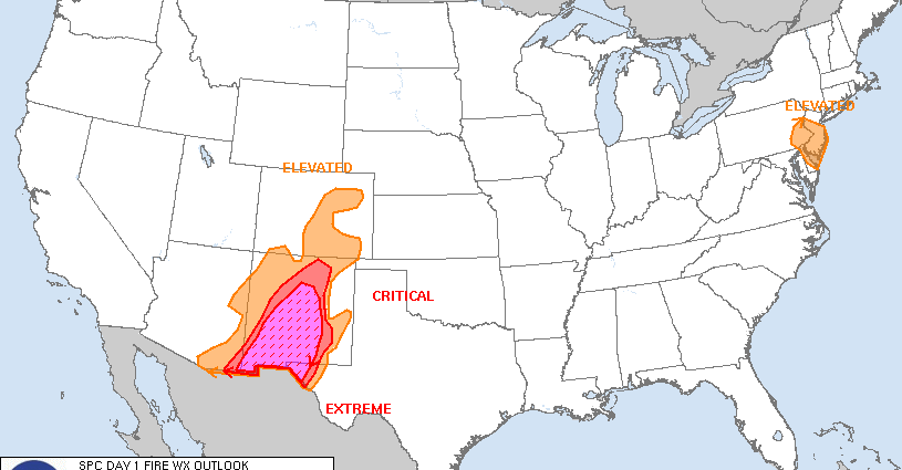
Day 1 Fire Weather Outlook
NWS Storm Prediction Center Norman OK
1138 AM CDT Sun Apr 27 2025

Valid 271700Z - 281200Z

...EXTREMELY CRITICAL FIRE WEATHER AREA FOR CENTRAL AND SOUTHERN NEW
MEXICO INTO FAR WEST TEXAS...
...CRITICAL FIRE WEATHER AREA FOR MUCH OF CENTRAL NEW MEXICO INTO
FAR WEST TEXAS...

...Southeast Pennsylvania and New Jersey...
Elevated highlights were added across portions of southeastern
Pennsylvania and New Jersey where strong offshore flow within a
post-frontal regime is ongoing. Northwest winds of 15-25 mph with
gusts up to 40 mph combined with relative humidity falling into the
25-35 percent range are expected through the early afternoon before
winds subside late afternoon. Rainfall over the last 48 hours was
spotty so pockets of receptive fuels remain, primarily in the New
Jersey Pinelands.

...Southwest and adjacent High Plains...
Significant fire weather threat remains across the Southwest with
swath of Extremely Critical highlights in place across much of
southern and central New Mexico. Elevated highlights were extended
into far southeastern Utah and far western Colorado to account for
some lower elevation receptive fuels. Otherwise, previous forecast
(see below) remains on track.

..Williams.. 04/27/2025

.PREV DISCUSSION... /ISSUED 0109 AM CDT Sun Apr 27 2025/

...Synopsis...
With a mid-level trough translating across the Intermountain West,
and a lee cyclone deepening over the central High Plains, strong
surface winds and deep boundary layer mixing are forecast across
much of the Southwest into the southern High Plains. Critical to
Extremely Critical fire-weather conditions are expected across much
of southern and central New Mexico, into portions of far West Texas.


...Central/Southern New Mexico into Far West Texas...
Widespread 30+ MPH winds and 5-10% relative humidity is anticipated
over much of southern, central, and even portions of eastern New
Mexico. While dry and windy conditions are anticipated further east
of the current highlights, recent wetting rainfall in eastern New
Mexico over the last several days will serve to limit the
receptiveness of fuels to wildfire ignition and spread. Therefore,
Critical and Extremely Critical highlights have been confined to
where fuels guidance shows ERCs exceeding the 90th annual
percentile, primarily across southern and central New Mexico.

...Eastern Colorado...
Elevated highlights have been maintained over eastern Colorado,
where dormant/fine fuels are anticipated to be receptive to wildfire
ignition and spread with an environment characterized by 10%
relative humidity and 15-20 MPH winds. Some recent wetting rainfall
has occurred across eastern Colorado, with areas receiving 0.75-2.0
inches of rainfall in the last 48 hours. The Elevated highlights in
this update reflect the driest areas receiving little to no
rainfall.

...Please see www.spc.noaa.gov/fire for graphic product...
SPC Day 1 Fire Weather Outlook
Day 1 Fire Weather Outlook
NWS Storm Prediction Center Norman OK
1138 AM CDT Sun Apr 27 2025

Valid 271700Z - 281200Z

...EXTREMELY CRITICAL FIRE WEATHER AREA FOR CENTRAL AND SOUTHERN NEW
MEXICO INTO FAR WEST TEXAS...
...CRITICAL FIRE WEATHER AREA FOR MUCH OF CENTRAL NEW MEXICO INTO
FAR WEST TEXAS...

...Southeast Pennsylvania and New Jersey...
Elevated highlights were added across portions of southeastern
Pennsylvania and New Jersey where strong offshore flow within a
post-frontal regime is ongoing. Northwest winds of 15-25 mph with
gusts up to 40 mph combined with relative humidity falling into the
25-35 percent range are expected through the early afternoon before
winds subside late afternoon. Rainfall over the last 48 hours was
spotty so pockets of receptive fuels remain, primarily in the New
Jersey Pinelands.

...Southwest and adjacent High Plains...
Significant fire weather threat remains across the Southwest with
swath of Extremely Critical highlights in place across much of
southern and central New Mexico. Elevated highlights were extended
into far southeastern Utah and far western Colorado to account for
some lower elevation receptive fuels. Otherwise, previous forecast
(see below) remains on track.

..Williams.. 04/27/2025

.PREV DISCUSSION... /ISSUED 0109 AM CDT Sun Apr 27 2025/

...Synopsis...
With a mid-level trough translating across the Intermountain West,
and a lee cyclone deepening over the central High Plains, strong
surface winds and deep boundary layer mixing are forecast across
much of the Southwest into the southern High Plains. Critical to
Extremely Critical fire-weather conditions are expected across much
of southern and central New Mexico, into portions of far West Texas.


...Central/Southern New Mexico into Far West Texas...
Widespread 30+ MPH winds and 5-10% relative humidity is anticipated
over much of southern, central, and even portions of eastern New
Mexico. While dry and windy conditions are anticipated further east
of the current highlights, recent wetting rainfall in eastern New
Mexico over the last several days will serve to limit the
receptiveness of fuels to wildfire ignition and spread. Therefore,
Critical and Extremely Critical highlights have been confined to
where fuels guidance shows ERCs exceeding the 90th annual
percentile, primarily across southern and central New Mexico.

...Eastern Colorado...
Elevated highlights have been maintained over eastern Colorado,
where dormant/fine fuels are anticipated to be receptive to wildfire
ignition and spread with an environment characterized by 10%
relative humidity and 15-20 MPH winds. Some recent wetting rainfall
has occurred across eastern Colorado, with areas receiving 0.75-2.0
inches of rainfall in the last 48 hours. The Elevated highlights in
this update reflect the driest areas receiving little to no
rainfall.

...Please see www.spc.noaa.gov/fire for graphic product...
4:56 pmApril 27, 2025