
SPC Day Fire Weather Outlook
SPC Day 2 Fire Weather Outlook
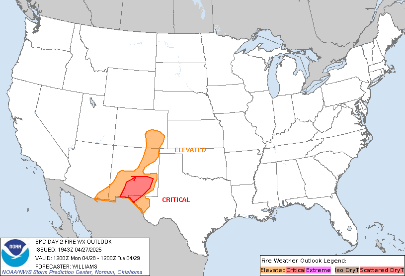
Day 2 Fire Weather Outlook
NWS Storm Prediction Center Norman OK
0243 PM CDT Sun Apr 27 2025

Valid 281200Z - 291200Z

...CRITICAL FIRE WEATHER AREA FOR SOUTHERN NEW MEXICO INTO FAR WEST
TEXAS...

...Southern New Mexico into far west Texas...
A lingering mid-level jet atop a very dry, well-mixed boundary layer
will result in west-southwest surface winds of 15-25 mph in addition
to single digit relative humidity across southern New Mexico into
far western Texas Monday afternoon. These conditions amid ERC values
at or exceeding the 97th percentile supports the addition of
Critical highlights.

...Southeastern Colorado...
Enhanced downslope winds and drying will support at least an
Elevated fire weather threat across southeastern Colorado through
early afternoon where the fuels seasonal green-up has been delayed.
Expect west-southwest surface winds of 15-20 mph and localized
single digit relative humidity through early afternoon before a dry
cold front arrives overnight.

..Williams.. 04/27/2025

.PREV DISCUSSION... /ISSUED 0358 AM CDT Sun Apr 27 2025/

...Synopsis...
A lingering mid-level trough over the western U.S. (and its
associated southwest flow), along with deep boundary layer mixing,
will result in at least Elevated fire-weather conditions across
portions of central and eastern New Mexico on Monday.

...Central and Eastern New Mexico...
With receptive fuels (ERCs exceeding the 80th-90th annual
percentiles) and dry, windy conditions across much of central and
eastern New Mexico, at least Elevated fire-weather conditions are
expected. 00Z HREF guidance suggests that there is potential for
Critical conditions, particularly across central New Mexico, but
there is enough ensemble spread in the HREF to preclude adding
highlights at this time. While the dry and windy conditions are
likely to occur further east into the Texas Panhandle, recent
wetting rainfall over the last several days should limit fire
danger.

...Please see www.spc.noaa.gov/fire for graphic product...
SPC Day 2 Fire Weather Outlook
Day 2 Fire Weather Outlook
NWS Storm Prediction Center Norman OK
0243 PM CDT Sun Apr 27 2025

Valid 281200Z - 291200Z

...CRITICAL FIRE WEATHER AREA FOR SOUTHERN NEW MEXICO INTO FAR WEST
TEXAS...

...Southern New Mexico into far west Texas...
A lingering mid-level jet atop a very dry, well-mixed boundary layer
will result in west-southwest surface winds of 15-25 mph in addition
to single digit relative humidity across southern New Mexico into
far western Texas Monday afternoon. These conditions amid ERC values
at or exceeding the 97th percentile supports the addition of
Critical highlights.

...Southeastern Colorado...
Enhanced downslope winds and drying will support at least an
Elevated fire weather threat across southeastern Colorado through
early afternoon where the fuels seasonal green-up has been delayed.
Expect west-southwest surface winds of 15-20 mph and localized
single digit relative humidity through early afternoon before a dry
cold front arrives overnight.

..Williams.. 04/27/2025

.PREV DISCUSSION... /ISSUED 0358 AM CDT Sun Apr 27 2025/

...Synopsis...
A lingering mid-level trough over the western U.S. (and its
associated southwest flow), along with deep boundary layer mixing,
will result in at least Elevated fire-weather conditions across
portions of central and eastern New Mexico on Monday.

...Central and Eastern New Mexico...
With receptive fuels (ERCs exceeding the 80th-90th annual
percentiles) and dry, windy conditions across much of central and
eastern New Mexico, at least Elevated fire-weather conditions are
expected. 00Z HREF guidance suggests that there is potential for
Critical conditions, particularly across central New Mexico, but
there is enough ensemble spread in the HREF to preclude adding
highlights at this time. While the dry and windy conditions are
likely to occur further east into the Texas Panhandle, recent
wetting rainfall over the last several days should limit fire
danger.

...Please see www.spc.noaa.gov/fire for graphic product...
3:45 pmApril 27, 2025